

Representatives from the federal agency are urging property owners to check whether their homes and businesses are contained within newly redrawn flood risk maps.
By Matt Skoufalos

Song advises a resident on FEMA flood maps. Credit: Matt Skoufalos.
You only have to go back as far as a year to recall the significance flooding can have in Camden County (and if you’re having trouble conjuring up the images, John Ziomek’s Courier-Post photo gallery of flooding on the Cooper River will take you back then in a jiffy), and yet some of the maps that the federal government uses to determine flood risk are much older than that.
Before Sandy uprooted trees and knocked power grids offline, even before Irene pounded low-lying areas of Collingswood, the Federal Emergency Management Agency (FEMA) was working to review its studies of flood-prone areas of the country, the better to calculate insurance risks from flood damage.
On Wednesday, representatives of the agency gathered at the Camden County boathouse along the Cooper River to walk area residents through the new flood insurance risk maps (FIRMs) and determine whether they would be obligated to purchase additional coverage for their homes.
“When the maps that exist now were developed, there was no true ability to do a coastal analysis,” said Thomas Song, FEMA Community Outreach Lead for New Jersey Coastal Communities.
“[For] this new study, we were able to do wave height analysis and take into consideration how the surge would affect these communities.”
Camden County was last mapped in 2008, Song said, but the new studies combine GPS and laser technology to measure ground elevation to a higher degree of accuracy.
All that specificity is designed, at the macro level, to engage local governments to become more active in identifying and comprehending their vulnerability to flood risk in the age of super-storms and hurricanes. At the individual level, it’s a chance to give homeowners a heads-up that the re-zoning process might obligate them to purchase flood insurance for their properties within the next 18 months or so.
“We’re trying to create a sense of transparency,” Song said. “All the information used for modeling is available online, so part of our outreach is engaging local officials, decision-makers, and telling them what the study does.
“We want them to learn about flood risk and how it affects them, and what actions to take,” he said.

Thomas Song. Credit: Matt Skoufalos.
Flood insurance, flood maps, flood risk
Homeowners insurance doesn’t cover flood risk, and the National Flood Insurance Program (NFIP), which is administered by FEMA, has undergone a pair of big reforms in the past three years.
The first of these, the Biggert-Waters Flood Insurance Reform Act of 2012, was an attempt to make NFIP more stable by raising flood insurance premiums in higher-risk areas.
Some of those increases were rolled back in the Homeowners Flood Insurance Affordability Act of 2014 (HFIAA).
But with the redrawing of these federal maps, property owners whose homes and businesses are now determined to lie within a special flood hazard area (SFHA) will bear more of the true actuarial cost of that insurance.
“If you are in a designated SFHA, and you’re carrying a mortgage that has some type of federal backing—Fannie Mae, Freddie Mac—your lender will make you purchase flood insurance,” Song said.
“Most lenders, if they find out your structure is in an SFHA, they’ll make you get it. Most people, if they’re in an SFHA, they know. They’re getting a bill.”
As per Congressional legislation, SFHA maps cover what FEMA calls “the 100-year flood,” or the 1 percent annual chance of a flood in the area. Property owners whose buildings are added to an SFHA have the opportunity of a 90-day statutory appeal, Song said, but their objections must be supported by technical research.
“We don’t take anecdotal data,” he said. “We would require some sort of modeling, engineering, surveying.”
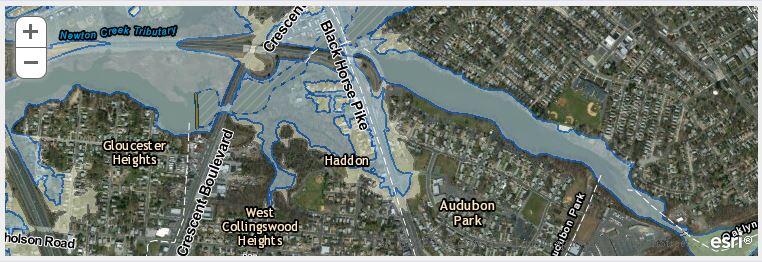
Screengrab from the Region2Coastal website showing new flood maps. Credit: FEMA.
When the SFHA maps become official—likely sometime in late 2016 or early 2017—“your mortgage company will probably get in touch with you,” he said. “They usually don’t miss that.”
Although Song says he has seen “the rare $10,000 insurance bill” for new coverage, he also added that “that doesn’t happen very often unless someone has made a mistake.”
Of course, he acknowledged, “any flood insurance where there wasn’t one before is [financially]burdensome.”
Residents looking to see if their properties are within an SFHA can punch their address into Region2coastal.com. There aren’t many homes in the area that are immediately included in the new maps, but, as Song points out, “It is important that if people live or think they live near a source of water that they should determine if they are at risk.”

Steven Ardito. Credit: Matt Skoufalos.
Grandfathered in at a preferred rate
When there is a mandatory flood insurance purchase because a property lies within an SFHA, the new HFIAA legislation makes such purchases somewhat more palatable, said Steven Ardito, FEMA Insurance Program Specialist.
“For those who are newly mapped in, what they need to know is they may qualify for a preferred risk policy (PRP),” Ardito said.
“If that’s purchased before the map adoption, they will be grandfathered into a standard B, C, X policy”—the designations given to zones that are not considered high-risk.
Without the protections of HFIAA, homeowners being mapped into an SFHA zone could have been required to purchase flood insurance policies at triple that preferred risk rate, he said.
“Yes it’s high, but it could be worse,” he said.
PRP plans start around $400-450 annually and ramp up to more than $2,100-2,600—or full actuarial value—along an 18-percent annual increase; those numbers, of course, will be greater due to inflation by the year 2030, when they reach “full risk rating,” Ardito said.
“As we’re showing many years to get to that full rate, there’s ample time for someone to consider a mitigation project,” such as installing flood vents, or filling in a basement, “in order to get a better rate,” he said.
Without making such improvements, even mandatorily, Ardito said, “what you’ve got is [a property]that’s not very marketable by 2030.
“That’s why we want people to consider mitigation,” he said, “not only for the resilience of the structure, but we also want the homes to be marketable. That’s the part that’s tough to get to.”
Ardito, an Ocean County resident, said that he’s seen homeowners victimized by flooding and by insurance policies that don’t pay out entitled benefits. HFIAA contains other remedies designed to support the insured, he said, including an affordability study of insurance policies, the establishment of an advocacy program for flood insurance policyholders, and redress for “fraudulent and questionable engineering activities” that lead to the denial of claims.
“This is all geared towards making the system work,” Ardito said. “Our desire and our goal is to pay every dollar that the insured is allowed or eligible for. If we can get to that goal, then everybody will have been treated fairly and ethically.
“It was big for us to admit that there were some problems with the system and to make corrective changes,” he said. “We’ve heard it before with the IRS, with the VA system, and nothing happens there. I truly believe we’re going to get there.
“But there are a lot of moving parts to this,” Ardito added. “It’s not just FEMA. We’re working with private insurance companies and private catastrophe adjusters. So it’s going to be us doing our part, but they have to do their part as well.”

Crystal Tramunti. Credit: Matt Skoufalos.
Financial incentives for community resiliency
On a county level, Ardito said, the new maps can help local governments identify flood risk areas and work to better plan evacuation routes, invest grant dollars into elevating roads and culverts, and acquire homes that lie in flood plains, the better to insulate their communities against flood risk.
In 1990, FEMA created the Community Ratings System (CRS), an incentive program that helps local governments draw up plans to shore up their infrastructure against flood damage and help residents save on insurance premiums.
“CRS is popular right now because it is a financial savings,” said Crystal Tramunti, FEMA Emergency Programs Specialist.
“It provides more flood protection by way of the actual community taking action. The resident can take action and do something with their structure, or the community can do something on the residents’ behalf.”
Communities that join CRS must first adopt an NFIP ordinance, which Tramunti describes as “the Cliff’s Notes version of the federal regulations” for floodplain management. In exchange, residents in a community that is NFIP-compliant are eligible for discounted rates on federally backed flood insurance, up to a maximum of 45 percent off full risk rates for top-tier communities.
“It’s only for the communities that are going above and beyond that ordinance,” Tramunti said.
Earning a CRS certification is difficult, however, and can even demand a full- or part-time position to deal with all the necessary paperwork to achieve the maximum benefits of the program, she said. Towns are scored on a scale of 10 to 1, with 1 being the best. Properties within CRS communities earn an additional 5-percent insurance discount per scale rating; the best in the region is Sea Isle City, which is a Class 5, Tramunti said.
Only 59 communities in New Jersey participate in the CRS system, and none of them is in Camden County (the closest is National Park).
If the opportunity of a discount weren’t enough incentive, Tramunti pointed out that “communities that aren’t in CRS are paying for the discounts for those communities in New Jersey that are in CRS.
“There’s a motivation, if you’re not a CRS community to get into it,” she said. “It’s forcing a community to become more resilient.”
To see where your property lies on the new flood insurance risk map, visit region2coastal.com.
Get more local news that matters. Check out NJ Pen on Facebook and Twitter.


